
Environment
Stell Simonton
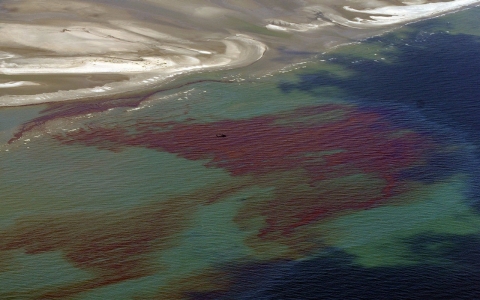
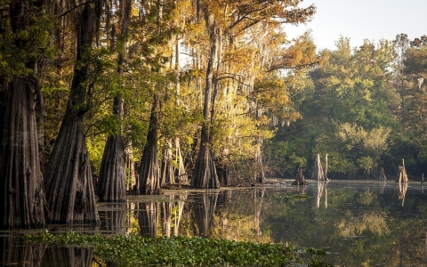
TERREBONNE PARISH, Louisiana — Streams of oil slid into the bayous of southeastern Louisiana after the Deepwater Horizon explosion in 2010, damaging the marsh grasses, the wildlife and the livelihood of the 17,000-member Houma tribe.
The pollution also weakened the marshes, accelerating the rapid disappearance of coastal land that is taking the Houma Indians’ culture with it.
Now money that BP, the oil and gas company responsible for the spill, was forced to pay is beginning to flow to some groups and businesses to repair the environmental damage and protect the coast. But the Houma Indians say they haven't been compensated for the damage to the land they live on and fear they won't see funding for the protection and restoration projects they consider important.
While the marshes have been eroding for years, due to levee building, oil pipelines and climate change, the Houma say the BP spill significantly worsened the problem.
The United Houma Nation is officially recognized by the state of Louisiana but not by the federal government, making it hard for the Houma to negotiate compensation.
“The United Houma Nation reached out to BP for assistance,” said Principal Chief Thomas Dardar Jr. in a congressional hearing in 2012. But because the Houma aren’t a federally acknowledged tribe, BP said it wasn’t mandated to help, he said. A BP representative declined to comment.
And yet the Houma and several other indigenous groups in the area — including the Grand Bayou Village, Grand Caillou/Dulac, Isle de Jean Charles and Pointe-au-Chien tribes — are faced with a startling loss.
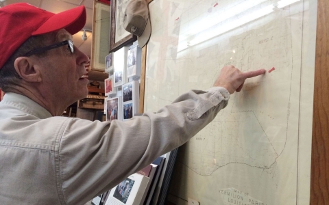
Dardar’s administrative assistant, Bette Billiot, drove her black minivan down a narrow road alongside Pointe-aux-Chenes Bayou in early December, the white feathers of a dreamcatcher swaying from her rearview mirror.
The bayou is in Terrebonne Parish, one of six coastal parishes where the Houma and other Native peoples are concentrated.
She pointed to the right. “That’s Lora Ann Chaisson’s property,” she said. Chaisson, the vice principal chief of the Houma, used to own 15 acres, but only 12 acres of her land still exist. “She has three acres of water now,” Billiot said.
Billiot turned the van onto a narrow road leading to Isle de Jean Charles, a stretch of land that was inspiration for the 2012 film “Beasts of the Southern Wild.”
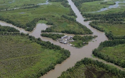
For years, it was home to a community of Native Americans. Once, 125 or so families lived there, she said. Now it’s only about 25 families. The island was 5 miles wide and 11 miles long in the 1950s, according to the U.S. Geological Survey. Now it’s barely a quarter of a mile wide and 2 miles long.
This area of southeastern Louisiana is simply melting away — an average of 16.57 square miles a year for the past 25 years, according to the Geological Survey.
It’s like losing the area of a football field every hour, said David Gauthe, a member of Bayou Interfaith Shared Community Organizing, a group of religious organizations concerned about environmental issues and poverty.
And it’s pushing Houma families out of the bayou.
The Louisiana coast has been eroding for nearly 100 years, but only recently have alarm bells been sounding.
Levees and dams on the Mississippi, built to control flooding beginning in the 1920s, had the unintended consequence of diverting silt that replenished the delta marshlands each year.
The discovery of oil in the 1920s brought oil and gas companies into the area. Since then, the industry has laid 10,000 miles of pipeline in the Louisiana wetlands to carry the oil to refineries. In addition, companies cut canals through the marsh, creating what Dardar called a checkerboard.
Storm surges from hurricanes then sent saltwater flowing through those channels, killing the freshwater plants in the marsh. Oil from the BP spill weakened the marshes and exacerbated the problem. On top of this, sea levels are rising because of climate change.
Aerial pictures once showed swaths of land laced with narrow ribbons of bayou. Now the area looks more like a giant spiderweb, with thin strands of land and wide expanses of water.
The oil and gas industry is responsible for 36 percent of the wetland loss, according to a study commissioned by the industry and published in 2000 (PDF). Sponsored by the Gas Research Institute in cooperation with the U.S. Geological Survey, it shows the amount land loss caused by various activities, from channel dredging to oil extraction.
And the industry doesn't want to pay; an unprecedented lawsuit against 97 oil and gas companies in Louisiana was filed in July 2013 by the board that oversees New Orleans flood protection.
The Southeast Louisiana Flood Protection Authority – East is suing companies such as ExxonMobil, ConocoPhillips, Shell, BP, Chevron and Koch Industries, saying their marsh destruction is what allowed the Hurricane Katrina storm surge to flood New Orleans so catastrophically.
But even if the lawsuit is successful, it’s unclear how or if the lawsuit would benefit the Houma.
The Houma Indians, who once lived in the area of Baton Rouge, moved down into the bayous back when the land was considered of little value. They went to avoid the 1830 Indian Removal Act and the Trail of Tears. In the marsh they established a self-sufficient way of life largely cut off from the rest of society until the 1950s.
In addition to fishing, they hunted and trapped the abundant game — rabbits, ducks, deer, mink and muskrat, according to Dardar. They developed a tradition of traiteurs, or healers, who provided medical treatment and spiritual guidance, he said. For transportation, the Native Americans built canoelike boats called pirogues from dugout cypress trunks. Children paddled to a mission school in pirogues; they were not allowed to attend public schools until the Louisiana schools were forced to racially integrate in the 1960s.
In spite of its long history, the tribe has been unsuccessful in gaining federal recognition. The United Houma Nation has spent 30 years seeking that status — and getting nowhere. It applied to the Bureau of Indian Affairs in 1985, but the application sat in inactive status for years before being rejected.
The General Accounting Office criticized the bureau in 2001 for its application backlog, which it could take up to 15 years to work through.
Kevin Washburn, assistant secretary of Indian affairs in the U.S. Department of the Interior, has acknowledged that the application process for federal recognition is broken. In May the department announced plans to change the requirements. Under the proposal, tribes would no longer have to document their continuous community and political influence as a tribe from “historical times” but only from 1934.
Now more than ever, the tribe needs the protections over its land that federal recognition would offer. This flat land where the sea and earth merge holds a central place in the shifting struggle over oil and climate change. Louisiana is the third-largest producer of petroleum in the United States and provides one-fourth of the nation’s natural gas.
The delta is a point on the globe that’s being pulled apart at the seams, under the pressure for oil and the process of climate change. The immediate victims are indigenous groups with relatively little power — and who are being termed environmental refugees by organizations such as the Climate Institute, a nonprofit based in Washington, D.C.
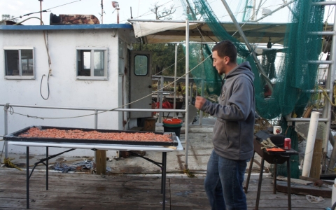
Early in December, three generations of the Verdin family went out crabbing
Anesie Verdin, 67, gave directions to his grandson Beau, 19, who steered their 36-foot aluminum-hull boat down Point-aux-Chenes Bayou. Wild horses grazed in the tall grass along the shore. The trunks of trees killed by saltwater rose above the grass, a visible reminder of the dying marsh. A group of flamingos took flight, a soft pink in the early morning sun.
Verdin’s son Ernie pulled in the crab traps, shaking out a few blue crabs that were caught. Out in the open water, a dolphin followed the boat.
As the boat re-entered the bayou, Verdin pointed beyond the marsh. “That used to be land. We used to trap for animals there. Now we fish for crabs in that same place.”
Louisiana is scrambling to address the severe coastline loss. A 50-year-plan that could cost $50 billion will bring in silt, build levees and nurture marsh regrowth.
As the Verdin boat headed back to the dock, David Gauthe, who was also on board, pointed out the new levee that is part of the Morganza flood-control structure of the Gulf Hurricane Protection System.
It doesn’t extend to Isle de Jean Charles, he said, which is effectively excluded by the coastal protection plan.
Later in the day, Verdin and his wife, Jane, went to the Dulac Community Center for a showing of a film made by their younger cousin Monique.
Monique’s film “My Louisiana Love” chronicles her deep love for the land and sense of loss and disconnection from it. Verdin said she was drawn to the old ways of her grandmother and other ancestors.
But “I’m inheriting a dying delta,” she says in the film.
Lanor Curole, project director of United Houma Nation, also expressed the loss. “How do you maintain a sense of your culture and community when the very land is disappearing underneath you?” she asked.
People may not care, she said, “until it’s their community.”
Residents in coastal areas say Louisiana’s government is laying claim to privately held land and mineral rights
Trial wraps up as Louisiana finds 20 times more oily material this year than last
A lawsuit against oil and gas companies for damage to the coast has become a symbol of the state’s environmental future

Louisiana residents say EPA regulations won’t stop them from getting sick. One solution: a buyout of their homes
Environmentalists say swaths of Southeastern woodlands are being cut down for green energy efforts across Atlantic


Error
Sorry, your comment was not saved due to a technical problem. Please try again later or using a different browser.