
Environment
Laura Buckman / AFP / Getty Images
The weather effects of El Niño, already blamed in large part for unusual winter floods, tornadoes and other extreme weather in the U.S., the U.K. and other countries during 2015, are far from over.
Scientists predict El Niño’s biggest effects will be felt in 2016.
“El Niño 2015 has already created weather chaos around the world,” NASA said in a Dec. 29 press release. Over the next few months, forecasters expect the United States to continue to feel its impacts, the release stated.
“We may not yet have seen the peak of this El Niño,” Josh Willis, a project scientist at NASA’s Jet Propulsion Laboratory (JPL), said in the release. More severe weather is predicted for the New Year, with scientists warning that El Niño is growing and its biggest effects are expected in early 2016.
The weather event — signaled by weaker westward winds in the Pacific Ocean and a warming of the eastern tropical Pacific — is set to rival the last large El Niño, in 1997, which this year’s pattern resembles.
But the current El Niño has caused far more heat and moisture to be pumped from the ocean into the atmosphere than in 1997 because of ocean warming caused by climate change.
For perspective, the El Niño–affected area of the Pacific is more than twice the size of the continental U.S.
Its impact has contributed to an outbreak of severe weather around the world in recent weeks — wreaking havoc in parts of the U.S, including major to record flooding this week along the Mississippi and Ohio rivers in Missouri, Illinois and Kentucky.
The warm, moist air coming off the Pacific — some of which was pushed to the North Pole, where it caused an unusually extreme rise in temperature this week — could lead to twice the average rainfall for California in the coming months, NASA’s release said.
That could mean relief for the currently drought-stricken West, but the precipitation may be accompanied by mudslides, floods, high winds, lightning strikes and high surf, the release said.
“The water story for much of the American West over most of the past decade has been dominated by punishing drought,” stated Bill Patzert, a JPL climatologist for NASA. “Reservoir levels have fallen to record or near-record lows, while groundwater tables have dropped dangerously in many areas. Now we’re preparing to see the flip side of nature’s water cycle — the arrival of steady, heavy rains and snowfall.”
Over the next several months, the National Oceanic and Atmospheric Administration predicts colder, wetter conditions in the southern U.S. and relatively warm and dry conditions in the much of the North — although there could be one or two isolated snowstorms.
In the Northwest and Northeast — which has largely been spared severe weather this season — rain and snow are forecast for Jan. 3, NOAA’s forecast added.
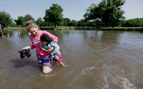
Scientists say ferocious storms that caused flooding in Texas and Oklahoma may be just the beginning of a very wet year

Flooding, record-high temperatures in US and UK linked to warm, moist air moving north from tropics and El Niño

Arctic temperatures have risen 1 to 2 degrees Celsius above freezing – an extremely rare occurrence
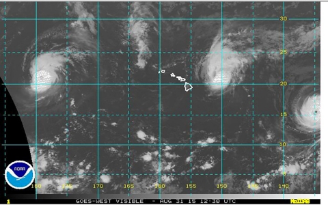
Never-before-seen meteorological event involves Category 3 and 4 hurricanes Ignacio, Jimena and Kilo


Error
Sorry, your comment was not saved due to a technical problem. Please try again later or using a different browser.