
Environment
Karl Fellenius / AFP / Getty Images
This is part one of a three-part series examining the effects of climate change on the Marshall Islands. Part two looks at what is being done to adapt to the increasing threats it poses.
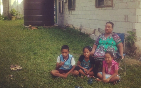
MAJURO, Marshall Islands — “They came and told us to evacuate to the next house, which is stronger, because there will be a flood. The tide went up to the front porch and I was scared because of the big waves,” said 7-year-old Keslynna Myo Sibok, a resident of Majuro, the capital of the Republic of the Marshall Islands — a remote chain of 29 low-lying coral atolls and five islands that lies in the middle of the Pacific Ocean and has found itself on the front lines of climate change.
Keslynna sat in the front yard of her grandmother’s home, located on their atoll’s most vulnerable edge, where there is nothing to protect it from increasingly unpredictable and severe inundations.
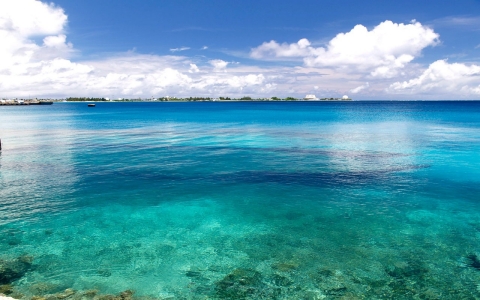
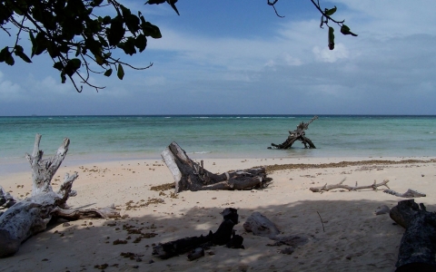
The atolls of the Marshall Islands are narrow and practically level with the sea, leaving their 68,000 residents nowhere to move to as a rising sea and increasingly frequent floods threatens to swamp the country. Unlike in many parts of the world where climate change often seems a distant threat, for the Marshallese it is already a daily reality.
Keslynna’s grandmother, Rusina Rusin, said the land has been in her family for too many generations to count, passed down from mother to daughter in the country’s matrilineal social system. She said she has noticed the increasing unpredictability of the weather.
“I’ve been living on the ocean so I can see a difference,” Rusin said. I believe it’s an effect of climate change.”
She said the Marshallese are “sea masters,” famed for navigational skills and intimate knowledge of the ocean that allowed them to find and settle the remote atolls thousands of years ago — but now no one can predict what the ocean will bring. Floods suddenly occur without the usual warning signals of storms, rain or wind, Rusin said.
The last flood happened in March; before that in February. But the worst inundation happened in spring last year, when water rushed through Rusin’s home and dragged household items — including Sibok’s prized doll house — out to sea.
“I had to go out to the reef to get my clothes and collect them along with a towel, buckets, and a chair,” Rusin said. She chuckled at that image, but quickly turned serious.
“I’m just a lowly grandmother and widow, not having anything precious except land and grandchildren, but every time it floods it affects the land and it costs me,” Rusin said. “I depend on the crops — the coconut trees, bananas and herbs for medicine — I could never manage a subsistence life if this continues.”
The elevation of the Marshall Islands averages just six feet, with many areas roughly at sea level. Rising waters have prompted residents to build piecemeal seawalls and earthen barriers that do little to stop flooding. During especially high tides, sandbags can be seen stacked around the Majuro airport runway and along some roads in especially low-lying areas.
“Our main concern, because we’re very low-lying, is inundation,” said Reginald White, a meteorologist at the Majuro Weather Service Office who studies climate-change trends including sea-level rise.
The type of risks the country faces from climate change vary depending on whether it is an El Niño or La Niña year — warm or cold phases in the equatorial Pacific Ocean, White said. During an El Niño, which scientists have predicted will occur throughout 2015, wave heights decrease by several inches, but the risk of typhoons is doubled. Conversely, wave heights increase by up to a foot during a La Niña, when increased rainfall can also trigger floods.
“My house got flooded,” White said, recalling the previous year. “Sea level could continue to rise, but when it is combined with spring tide, La Niña and even a moderate storm surge, there will be a major inundation event.”
Floods exacerbated by rising sea levels can taint the country’s limited water resources with salt, as well as damaging its scarce agricultural land.
Seas are rising in the Marshall Islands at least twice as fast as the global average, according to tide gauges and satellite data provided by the country’s government — echoing reports by researchers in other countries who have found indications of regional differences in sea level rise.
The United Nations Intergovernmental Panel on Climate Change last year warned of an average three-foot sea level rise by the end of this century. But with new insight into melting glaciers in West Antarctica and Greenland, other researchers have said that number should be revised to at least six feet — which would swamp much of the Marshall Islands.

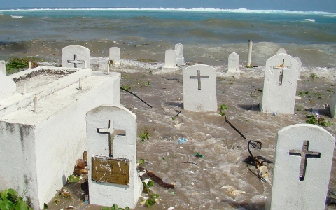
The danger is evident in Rita, the part of Majuro where Rusin and her granddaughter live. American soldiers nicknamed it after actress Rita Hayworth during the decades of U.S. occupation after World War II.
A row of half-destroyed and abandoned homes lines the beach, and down the road a graveyard perches precariously on the coast with above-ground concrete tombs — some of which have tipped into the ocean from floods and erosion in recent years. Many remains from this and other graveyards in Majuro have already been lost to the sea in previous floods, residents said.
“The museum has, I don’t know how many, boxes of skeletons they collected. The graveyard in Laura is now underwater,” said Amatlain Kabua, the country's former U.N. ambassador and former mayor of Majuro. She was referring to the other end of the atoll, nicknamed after the late actress Lauren Bacall.
Evelyn Lanki, city clerk on the Majuro city council, said that the waves of the last flood in Rita carried large rocks that destroyed many homes, and that another large flood would knock down the remaining abandoned houses.
“This place was a mess,” Lanki said, adding that floods have increased and become unpredictable, no longer following the pattern of wet and dry seasons. “We can feel it,” she said. “Nothing happens seasonally anymore.”
One potentially disastrous event that can still be predicted is the annual King Tide, the highest of the year. Residents said that in the past most of them wouldn’t even know the exact date the top tide occurred because it didn’t cause significant flooding — but in March 2014 a King Tide combined with a storm surge swept the sea over Majuro atoll and through the streets of the capital. Hundreds of stunned residents were evacuated from their homes.
“This year everyone knew the King Tide was on Feb. 19 — this never happened before,” said Jack Niedenthal, who holds the title of trust liaison for the people of the Marshall Islands’ Bikini Atoll, located about 500 miles northeast of the capital. Its local government was moved to Majuro before the United States carried out nuclear testing there from 1946 to 1958.
In Majuro this year, earthen barriers were built and sandbags piled along the lagoon and ocean on the narrow atoll in preparation for the King Tide, and the government stood by with emergency equipment, Niedenthal said.
“It was like someone pushed a button and the waves just exploded, gushing over the walls,” Niedenthal said. He added that even the normally predictable King Tide caught residents off-guard this year because it occurred twice — once in January and again in February. The January King Tide also led to the flooding of large areas of Majuro.
Niedenthal, who advises the Bikini government on nuclear testing compensation issues, said that despite the islanders’ legacy of illness and displacement, climate change has them “really freaked out."
Ahead of nuclear tests, the U.S. had relocated some Bikini Atoll residents to Kili, an Marshal Islands atoll about 185 miles southeast of Majuro. In 2011 floods left Kili “fully underwater,” Niedenthal said, adding that the saltwater destroyed much of the island's agriculture and affected its drinking water supplies. Severe floods have already struck Kili twice this year.
The Kili flooding highlighted the challenges a developing country such as the Marshall Islands faces in responding to climate emergencies in its remote areas. Many of the country’s outer atolls can only be reached quickly by chartered flights — which would become impossible if runways are flooded — or by boat, which can take days or even weeks.
“Kili Island was inundated,” said Marshal Islands President Christopher J. Loeak, adding that water had even risen from beneath the island and up through its coral, worsening the flooding from waves and rising seas.
“We’re doing as much as we can, but we always need more help,” Loeak added. “It’s disaster after disaster."

Marshall Islands president issues a call to action ahead of international climate summit next week hosted by the UN
Marshall Islands president tells negotiators from 30 countries that his people 'stand to lose everything'
Marshall Islands VP tells Al Jazeera it’s time for the ‘big guys’ to sign on to measures to save low-lying nations
Leaders from nations most affected by climate change sign declaration pledging to reduce emissions

Former UN climate chief says ‘no such thing as safe rise’; scientists fear tipping point will be passed

On top of report of ‘unstoppable’ glacial melt in Antarctica, experts say oceans rising faster than once predicted


Error
Sorry, your comment was not saved due to a technical problem. Please try again later or using a different browser.