
U.S.
Jessica Brandi Lifland / Polaris
LOS ANGELES — California’s historic drought is in its fourth year and gloom-and-doom scenarios of its impact on everything from killing the state’s vegetation and triggering bug infestation to destroying farming jobs have been trickling in daily.
Now, there is another fear: The prolonged drought may have weakened California’s more than 13,000 miles of levees, which could result in floods and affect the quality of water for millions of Californians.
That’s a scary prospect for parts of the state that could get doused with torrential rain this winter, thanks to an El Niño weather front triggered by unusually warm Pacific Ocean temperatures. And the mere mention of levee breaks evokes terrifying images of the devastation Hurricane Katrina wreaked on New Orleans 10 years ago.
A Mississippi State University civil engineer sounded the alarm in a recent article in Science magazine.
“If the drought ends with heavy rainfall-induced flooding, as seen in 2010 in Australia and 2015 in Texas and Oklahoma, the levees could be at even greater risk,” said Farshid Vahedifard, the article’s lead writer and an assistant professor at the university’s department of civil and environmental engineering
“The drought weakens the soil, will form some cracks and decrease the strength of the levees, bridges or any infrastructure,” he said. “Water is an enemy for soil … California levees are very vulnerable and became worse due to the drought.”
Levees built on peaty soil are especially at risk, he said, because they face faster decomposition of the soil. The sand-clay mixture goes through organic carbon decomposition, land subsidence and erosion — all of which undermines the strength of the entire structure and increase the risk of water rising over the top of the levees, he warned.
Prolonged droughts undermine the stability of levees by increasing water seepage through cracking soil and weakening it, he said.
State flood management officials scoff at these dire warnings.
“There are somewhere between 13,000 and 14,000 miles of levees,” said Michael Mierzwa, California’s lead flood management planner. “When you get to the peat levees, we have about 1,100 miles.”
Out of that, about 300 miles are state project levees and the rest are local. And most of these levees are in the Sacramento-San Joaquin River Delta, an inland river delta and estuary in northern California. The levees are more like dykes.
“Those levies are wet year round,” Mierzwa said
Most are in agricultural areas, where there’s been feverish pumping for groundwater during this drought. That has resulted in the ground sinking.
Last month, NASA’s Jet Propulsion Laboratory released a report that show that the ground in California’s Central Valley is fast subsiding.
“These levees are constantly below water and the statement that the foundations would be dry is inaccurate,” Mierzwa said.
And if there were any flooding, it would occur on farmland and not in populated areas, he said.
But there is one concern. The levees are critical to the state’s water distribution and if there is any seepage, water quality could be compromised.
“Twenty-three to 25 million people are dependent on water that passes through these levees,” Mierzwa said “If, for some reason those levees fail, the risk of outage of the water supply is much greater in drought conditions.”
Kjeldsen, Sinnock & Neudeck, Inc., a civil engineering and land surveying company, provides services to public and private clients throughout California.
“The drought has no impact on those (peat) soils,” said Christopher Neudeck, principal engineer. “The saturation system is pretty much the same. … The quality may change. There may be a greater degree of salinity and chloride because the freshwater mixing is not the same.”
Vahedifard argues that the problem could be broader because California levees were not in great shape, even before the drought.
He cites the National Levee Database that shows that only 10 percent of the 744 levees listed were rated acceptable. In California, about 99 percent of the levees are rated “minimally acceptable.”
A 2011 report by the California Department of Water Resources — before the severe drought began — shows that 56 percent of the state’s levees were rated “high hazard”, which means “they are in serious danger of falling during an earthquake or flood event,” Vahedifard said.
Neudeck calls the Science article “alarmist.”
“We might have some cracking in our system because we haven’t seen water in our system for a while,” he said. “But I don’t see the drought having an immediate impact.”
Some of the poor ratings issued by the U.S. Army Corps of Engineers are an overreaction to the Katrina debacle, Neudeck said.
“They were embarrassed by Katrina,” he said. “Now, we’re being judged by standards we’ve never seen ever in the past. The standards are over-reaching. … Are they (levees) in great condition? No. But they’re manageable and we’re very aware of the integrity of our systems.”
There is no doubt that big, sudden storms can lead to flash flooding. Already this month, flash floods caused by heavy rains and hail killed one Californian. A hiker in the San Bernardino National Forest tried to cross a waist-deep river and was swept away. Another man survived being swept in a storm drain in San Bernardino County.
“During drought, levees tend to dry out,” says Jeffrey Mount, founding director of the Center for Watershed Sciences at the University of California Davis and a senior fellow with the Public Policy Institute of California. “This causes cracking and oxidation of organic material, both of which can lead to slumping and subsidence, often once the water returns.”
Mount is critical of the article’s “blanket assertions” but admits that the warnings should be heeded,
“In California, we have not been monitoring this in the thousands of miles of levees that we have,” Mount said. “We lack the resources to do this and, appropriately enough, when we are in the middle of a drought, we tend not to focus on floods. Yet, it’s precisely during a drought that we should be working on flood protection. When the floods come, it’s too late to do anything about them.”
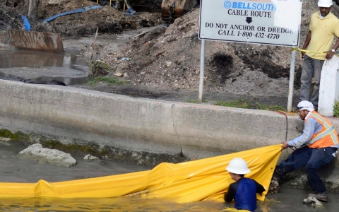
What the drought and the impending El Niño are doing is intensifying emergency response preparations. Northern California’s San Mateo and Santa Clara counties created the Joint Powers Authority (JPA) to prepare for overflowing creeks by shoring up the banks the San Francisquito Creek. Roofing companies are reporting record business as homeowners brace for an El Niño deluge.
“Climate change is actually a consideration in the design and maintenance” of levees, Mierzwa said, and he agrees with the article’s call for multi-hazard disaster risk science.
That’s been happening, he said. The California Department of Water Resources and U.S.Army Corps of Engineers have worked on a levee evaluation system. California’s Delta Stewardship Council is embarking on a Delta levee investment strategy.
Vahedifard said the need for research on the impact of drought on levees is urgent.
“We do know levees are not in good shape,” he said. “We’re not trying to blame anybody. We’re saying we have to take this issue seriously to make sure we don’t have another levee failure like what happened after Katrina.”
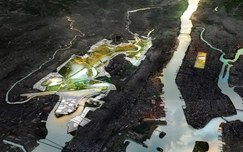
A federal design competition could radically alter our relationship with the water's edge
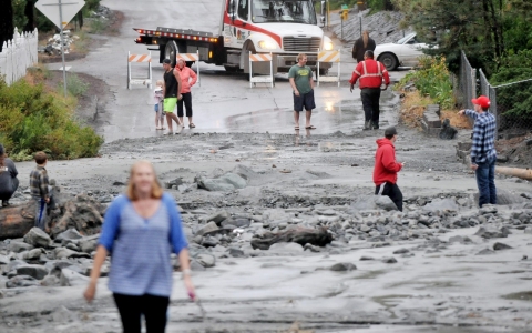
Unusual torrential rain blamed for bridge collapse on major highway as parched state sees flash floods
Higher sea levels due to climate change could soon inundate much of America’s waterfront real estate


Error
Sorry, your comment was not saved due to a technical problem. Please try again later or using a different browser.