
How Google is transforming disaster relief
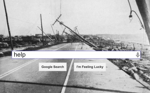
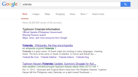
Since Typhoon Haiyan tore through the central Philippines earlier this month, loved ones around the world have posted more than 107,000 names to Google’s Person Finder. Missing-person lists are nothing new, but in any given disaster, they were often difficult to search or find at all. If relief work could be considered an industry, then Person Finder is an example of what Google does best: disrupt an inefficient one.
“We try to use friendly terms, disruptive has negative connotations,” Pete Giencke, an engineer on the Google Crisis Response team, told America Tonight.
Google isn’t trying to beat down the competition, but help it scale up.
“These organizations spring up, and they’re doing the right thing," Giencke said. "The easiest tool, maybe it’s a spreadsheet, maybe it’s Facebook. These tools don’t scale very well – 200,000 names in a spreadsheet, a Facebook page with 10,000 posts.”
Out of many, one

Google Person Finder was developed after the 2010 Haiti earthquake, which left 158,000 dead, according to a report by researchers from the U.S., Canada and Switzerland. More than a dozen missing-person databases appeared after the tragedy, and distraught families and friends had to sift through them all, posting desperate inquiries on each.
“We saw there was a clear need for better organization and synchronization across those efforts,” Giencke said.
One Google software engineer, Ka-Ping Yee, made it his personal project, building Person Finder in just 72 hours. The tool pulled in the information from all the existing missing-person lists, which allowed users to search them all at once. Within 24 hours, Google also obtained high resolution satellite photos, making it the first organization to release impact maps to the public. The Internet giant also collected aerial imagery with resolution as fine as 15 centimeters, which became critical for organizations making damage assessments and deciding where to set up clinics and send aid.
Google can do maps
Mapping is one of Google’s most glittering talents. It’s made, or helped others make, 360-degree computerized maps of great swaths of the globe. In 2008, Google enabled volunteers to contribute data about regions that Google Maps couldn’t reach, and Pakistani users quickly became the most enthusiastic amateur mappers in the world. When flooding submerged 20 percent of the country in August 2010, the U.N.’s mapping agency relied on that data to help coordinate emergency response.
The Google Crisis Map is regularly updated by people on the ground with information on evacuation centers, relief drop zone areas, road washouts and infrastructure damage, so residents and relief workers can better navigate crisis terrain.

As a geographic information systems data engineer, making these maps is Giencke’s job. In fact, mapping is what brought Giencke to Google. “I’m really big into World War II history. I love historical maps... You can tell these stories with a map, like, ‘Here is what Berlin looked like in 1945, before and after,’” Giencke said. “...When Google Maps came out in 2005, I fell in love. I thought, ‘Yes, this is the way of the future.’”
Giencke now works for the premier cartographer of the 21st century, helping to tell the most dramatic before and after stories that Mother Nature dreams up.
Searching for relief
Google didn’t set out to be a major player in emergency response. It just so happens that in emergencies, there’s a spike in Google usage.
Since Hurricane Katrina, Google has compiled things like emergency numbers, news updates and invitations to donate onto landing pages, which come up if you’re Googling about the disaster, or from the country where it struck. Since Haiti, the work became formalized as the Google Crisis Response team, a “small, scrappy” band, as Giencke puts it, based at the company’s headquarters in Mountain View, Calif., New York and Sydney, Australia.
Since Haiti, the Google Crisis Response team has responded to 25 more disasters. When Japan was ripped up in 2011 by the biggest earthquake in its history, Person Finder was live within 90 minutes. The tool compiled more than 600,000 names and received 36 million page views in the first two days, according to Shona Brown, senior vice president of Google.org, the company's philanthropic arm, in 2011 congressional testimony. Normally, that kind of volume would crash a website without the infrastructure of an entity like Google.
The Internet has increasingly become a critical part of response efforts, in no small part because it’s often still running when phone lines are down and cell phone towers are overwhelmed. After the Boston Marathon bombing this spring, Kelly Manning told Search Engine Journal that she tried calling her daughter for half an hour, without any luck. Then, she hopped on Person Finder, and located her immediately.
“If it wasn’t for Google Person Finder, we would have had no idea if she was ok and safe,” she said.
Still, Brown said that Google's work in emergency relief is modest, saying that the Crisis Response team doesn't claim to be an expert in crisis response.
“We are computer scientists and developers," she said, "and Google.org is a newcomer to this space."
Disaster relief 2.0
In the next few years, digital emergency response will become even faster, more flexible and more crowd-sourced. In times of crisis, Twitter and Facebook have already become go-to destinations for real-time updates, as well as outlets for collective mourning and doctored disaster pics. The day after the earthquake and tsunami hit Japan, tweets spiked at 5,000 per second five separate times.
Most disaster tweets, though they may be cathartic or thoughtful, aren’t exactly useful. But many of them are. One study of 64,000 disaster tweets from the Thailand’s 2011 floods, the fourth costliest natural disaster in history, according to World Bank estimates, found that 39 percent of them contained valuable location-based information and alerts.
And if people were willing to turn on geo-tagging on Twitter during an emergency (the vast majority of people keep their geo-tagging off), it would be possible to create dynamic maps from people's tweets, tracking everything from fallen trees to food deliveries to looting.

The power of social media in disaster relief has already been recognized by the Red Cross, which in collaboration with Dell and with the support of FEMA and the White House, launched a new Digital Operations Center in March 2012. While government officials will continue to make regular announcements in the wake of a disaster, average citizens who want the most current and relevant information will increasingly turn to each other instead.
Google isn’t the Red Cross. It doesn’t have an enormous logistics operation at the ready to bring water and food and antibiotics to people in need. But the foundation of crisis response is information, and Google’s speciality is getting information to the people who need it as quickly and easily as possible – whether it’s the best bang-for-your-buck plumber in Reno, Nev., or after a disaster, figuring out whether your grandmother is alive.
“Say organization Z has water and individual Z needs water,” Giencke said. “How do we connect those dots?”


Error
Sorry, your comment was not saved due to a technical problem. Please try again later or using a different browser.